
Mars Odyssey arrived at Mars on 24 October 2001. The spacecraft was inserted into an 18.6 hour elliptical capture orbit. Aerobraking was initiated during ODY's 10th orbit. Aerobraking continued until 11 January, 2002, coinciding with ODY's 336th orbit. At that time the orbit was a 2-hour near polar orbit with 400 km radius. Mapping science began on January 30, 2002. The spacecraft carried the Mars Radiation Environment Experiment (MARIE), the Thermal Emission Imaging System (THEMIS), and the Gamma-Ray Spectrometer (GRS). These data are stored in the Geosciences Node node.
Basic Mission Goals
The primary science goals were to gather data to further clarify the life-supporting qualities of the Martian environment, to characterize the climate and geology of Mars and to study potential radiation hazards to possible future astronaut missions. Odyssey was also designed to provide a communications relay for future missions to Mars.
For more information on the mission see the following links:
Mission Description
Spacecraft Description
Useful Mission Documents
References
Tolson, R., et al., Application of Accelerometer Data to Mars Odyssey Aerobraking and Atmospheric Modeling, Journal of Spacecraft and Rockets, Vol 42, No. 3, pp. 435-443, 2005
Description of the DATA
For each drag pass (spanning orbits 10 - 336 of the mission) there is an individual ASCII Profile file containing derived density values at 1-second intervals for a time period spanning several hundred seconds centered upon the periapse time. There is also a separate ASCII Altitude file which provides derived density and scale height values at specified altitudes (100 km, 110 km, etc.) for both the inbound and outbound portions of the orbit/drag pass as well as at the periapsis altitude, and 1.26 nanobar pressure level during both the inbound and outbound portions of the orbit/drag pass
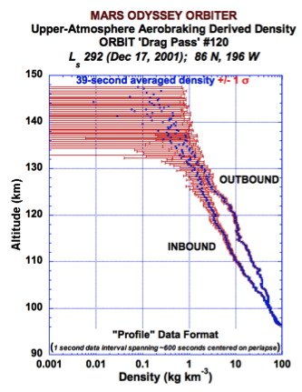
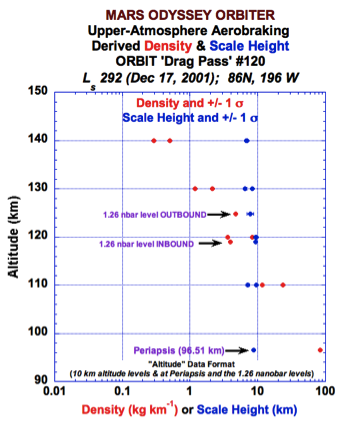
The data contained within the Ody aerobraking pds archive odya_0001 are provided in either the Altitude or Profile folders within the DATA folder. Within both the Profile and Altitude folders a user will find subfolders containing ~100 drag passes of data, with each drag pass consisting of a single ASCII file. For instance, the data presented in the left figure above are from the L2P120.TAB file located within the P100_199 folder within the Profile folder, while the data presented in the right-side figure above are located in the L3P120.TAB file located in the P100_199 folder located within the Altitude folder. RAW ODY accelerometer data are also available within their own folder below the Data folder. The contents and structure of the TAB files are described within text within those data file.
Retrieving the data bundle
Calibrated Data
Data can be retrieved at the file level - download the index, (csv) select the desired files and submit a list of URNs.
Example of Data (Partial file)
Orbit 99
Accelerometer Altitude data description
Accelerometer Altitude data
Data can be retrieved at the file level - download the index, (csv) select the desired files and submit a list of URNs to retrieve the data Link this to a page to retrieve the data.
Orbit 99
Example of Data
Raw Data
Similar aerobraking archives are available for the MGS and MRO orbiter missions.
Citing the data for Publication
R.H. Tolson, J.R. Murphy, R.F. Beebe and L.F. Huber (2007), ODY-M-ACCEL-5-PROFILE-V2.0, NASA Planetary Data System, https://doi.org/10.17189/1518936.
Basic Mission Goals
The primary science goals were to gather data to further clarify the life-supporting qualities of the Martian environment, to characterize the climate and geology of Mars and to study potential radiation hazards to possible future astronaut missions. Odyssey was also designed to provide a communications relay for future missions to Mars.
For more information on the mission see the following links:
Mission Description
Spacecraft Description
Useful Mission Documents
Description of data volume
Mission, Spacecraft and Instrument Description (PDF)
Report on Data Processing (pdf)
Ancillary Information
Calibration Data
Mission, Spacecraft and Instrument Description (PDF)
Report on Data Processing (pdf)
Ancillary Information
Calibration Data
References
Tolson, R., et al., Application of Accelerometer Data to Mars Odyssey Aerobraking and Atmospheric Modeling, Journal of Spacecraft and Rockets, Vol 42, No. 3, pp. 435-443, 2005
Description of the DATA
For each drag pass (spanning orbits 10 - 336 of the mission) there is an individual ASCII Profile file containing derived density values at 1-second intervals for a time period spanning several hundred seconds centered upon the periapse time. There is also a separate ASCII Altitude file which provides derived density and scale height values at specified altitudes (100 km, 110 km, etc.) for both the inbound and outbound portions of the orbit/drag pass as well as at the periapsis altitude, and 1.26 nanobar pressure level during both the inbound and outbound portions of the orbit/drag pass
The data contained within the Ody aerobraking pds archive odya_0001 are provided in either the Altitude or Profile folders within the DATA folder. Within both the Profile and Altitude folders a user will find subfolders containing ~100 drag passes of data, with each drag pass consisting of a single ASCII file. For instance, the data presented in the left figure above are from the L2P120.TAB file located within the P100_199 folder within the Profile folder, while the data presented in the right-side figure above are located in the L3P120.TAB file located in the P100_199 folder located within the Altitude folder. RAW ODY accelerometer data are also available within their own folder below the Data folder. The contents and structure of the TAB files are described within text within those data file.
Retrieving the data bundle
Calibrated Data
Data can be retrieved at the file level - download the index, (csv) select the desired files and submit a list of URNs.
Example of Data (Partial file)
Orbit 99
| Time from Periapse (sec) | Latitude (deg) | Longitude (deg) | Local Solar Time (hr) | Solar Zenith Angle (deg) | Altitude (km) | Density (kg/km**3) | Sigma Density (kg.km**3 | ||||||||||||||||
| -328.9 | 72 | 244.7 | 3 | 125.9 | 205.37 | -0.103 | 0.627 | ||||||||||||||||
| -327.9 | 72.1 | 244.6 | 3 | 125.8 | 204.73 | 0.054 | 0.627 | ||||||||||||||||
| -326.9 | 72.1 | 244.6 | 3 | 125.8 | 204.08 | -0.288 | 0.629 | ||||||||||||||||
| -325.9 | 72.2 | 244.5 | 3 | 125.8 | 203.45 | 0.062 | 0.627 | ||||||||||||||||
| -324.9 | 72.3 | 244.5 | 2.9 | 125.7 | 202.81 | -0.06 | 0.627 | ||||||||||||||||
| -323.9 | 72.3 | 244.4 | 2.9 | 125.7 | 202.17 | -0.037 | 0.627 | ||||||||||||||||
| -322.9 | 72.4 | 244.4 | 2.9 | 125.7 | 201.54 | -0.051 | 0.627 | ||||||||||||||||
| -321.9 | 72.5 | 244.3 | 2.9 | 125.7 | 200.91 | 0.196 | 0.628 | ||||||||||||||||
| -320.9 | 72.5 | 244.3 | 2.9 | 125.6 | 200.28 | -0.208 | 0.628 | ||||||||||||||||
| -319.9 | 72.6 | 244.2 | 2.9 | 125.6 | 199.65 | 0.214 | 0.628 | ||||||||||||||||
| -318.9 | 72.7 | 244.2 | 2.9 | 125.6 | 199.02 | -0.111 | 0.627 | ||||||||||||||||
| -317.9 | 72.7 | 244.1 | 2.9 | 125.5 | 198.4 | 0.126 | 0.627 | ||||||||||||||||
| -316.9 | 72.8 | 244.1 | 2.9 | 125.5 | 197.78 | -0.268 | 0.629 | ||||||||||||||||
| -315.9 | 72.9 | 244 | 2.9 | 125.5 | 197.16 | 0.238 | 0.629 | -320.9 | 72.5 | 244.3 | 2.9 | 125.6 | 200.28 | -0.208 | 0.628 | ||||||||
| -319.9 | 72.6 | 244.2 | 2.9 | 125.6 | 199.65 | 0.214 | 0.628 | ||||||||||||||||
| -318.9 | 72.7 | 244.2 | 2.9 | 125.6 | 199.02 | -0.111 | 0.627 | ||||||||||||||||
| -317.9 | 72.7 | 244.1 | 2.9 | 125.5 | 198.4 | 0.126 | 0.627 | ||||||||||||||||
| -316.9 | 72.8 | 244.1 | 2.9 | 125.5 | 197.78 | -0.268 | 0.629 | ||||||||||||||||
| -315.9 | 72.9 | 244 | 2.9 | 125.5 | 197.16 | 0.238 | 0.629 | ||||||||||||||||
| -314.9 | 72.9 | 244 | 2.9 | 125.4 | 196.54 | -0.137 | 0.628 | ||||||||||||||||
| -313.9 | 73 | 243.9 | 2.9 | 125.4 | 195.92 | 0.195 | 0.628 | ||||||||||||||||
| -312.9 | 73.1 | 243.9 | 2.9 | 125.4 | 195.3 | -0.059 | 0.627 | ||||||||||||||||
| -311.9 | 73.1 | 243.8 | 2.9 | 125.4 | 194.69 | 0.016 | 0.626 |
Accelerometer Altitude data description
Accelerometer Altitude data
Data can be retrieved at the file level - download the index, (csv) select the desired files and submit a list of URNs to retrieve the data Link this to a page to retrieve the data.
Orbit 99
Example of Data
| Altitude (km) | Latitude (deg) | Longitude (deg) | Local Solar Time (hr) | Longitude of Sun (deg) | Solar Zenith Angle (deg) | Density (kg/km**3) | Sigma Density (kg/km**3) | Scale Height (km) | Sigma Scale Height (km) | |||||||||||||||||||||||
| Periapse | 96.2 | 83.28 | 107.74 | 17.92 | 291 | 113.39 | 71.69 | 0.01 | 7.37 | 0.52 | ||||||||||||||||||||||
| 1.26 nbar inbound | 115.03 | 84.58 | 210.33 | 0.72 | 291 | 118.97 | 3.87 | 0.05 | 9.36 | 0.3 | ||||||||||||||||||||||
| 1.26 nbar outbound | 122.33 | 72.29 | 85.7 | 16.49 | 291 | 105.93 | 4.72 | 0.11 | 7.72 | 0.48 | ||||||||||||||||||||||
| inbound | 100 | -1 | -1 | -1 | -1 | -1 | -1 | -1 | -1 | -1 | ||||||||||||||||||||||
| outbound | 100 | -1 | -1 | -1 | -1 | -1 | -1 | -1 | -1 | -1 | ||||||||||||||||||||||
| inbound | 110 | 85.52 | 200.31 | 0.06 | 291 | 118.23 | 6.83 | 0.26 | 7.96 | 0.82 | ||||||||||||||||||||||
| outbound | 110 | 75.32 | 88.43 | 16.66 | 291 | 107.96 | 21.85 | 0.46 | 9.71 | 0.68 | ||||||||||||||||||||||
| inbound | 120 | 83.64 | 220.22 | 1.38 | 291 | 119.69 | 2.15 | 0.05 | 7.75 | 0.52 | ||||||||||||||||||||||
| outbound | 120 | 72.77 | 86.05 | 16.52 | 291 | 106.26 | 6.39 | 0.04 | 7.34 | 0.11 | ||||||||||||||||||||||
| inbound | 130 | 81.84 | 228.93 | 1.95 | 291 | 120.83 | 0.54 | 0.01 | 6.99 | 0.2 | ||||||||||||||||||||||
| outbound | 130 | 70.71 | 84.56 | 16.42 | 291 | 104.87 | 1.82 | 0.02 | 8.08 | 0.24 | ||||||||||||||||||||||
| inbound | 140 | 80.19 | 233.81 | 2.27 | 291 | 121.78 | 0.14 | 0.01 | 7.47 | 1.36 | ||||||||||||||||||||||
| outbound | 140 | 68.94 | 83.48 | 16.36 | 291 | 103.68 | 0.51 | 0.01 | 7.89 | 0.28 |
Raw Data
Similar aerobraking archives are available for the MGS and MRO orbiter missions.
Citing the data for Publication
R.H. Tolson, J.R. Murphy, R.F. Beebe and L.F. Huber (2007), ODY-M-ACCEL-5-PROFILE-V2.0, NASA Planetary Data System, https://doi.org/10.17189/1518936.
