
Apr 5, 2006 (Ls 34.7 MY 28) to Aug 30, 2006 (Ls 99.6 MY 28)
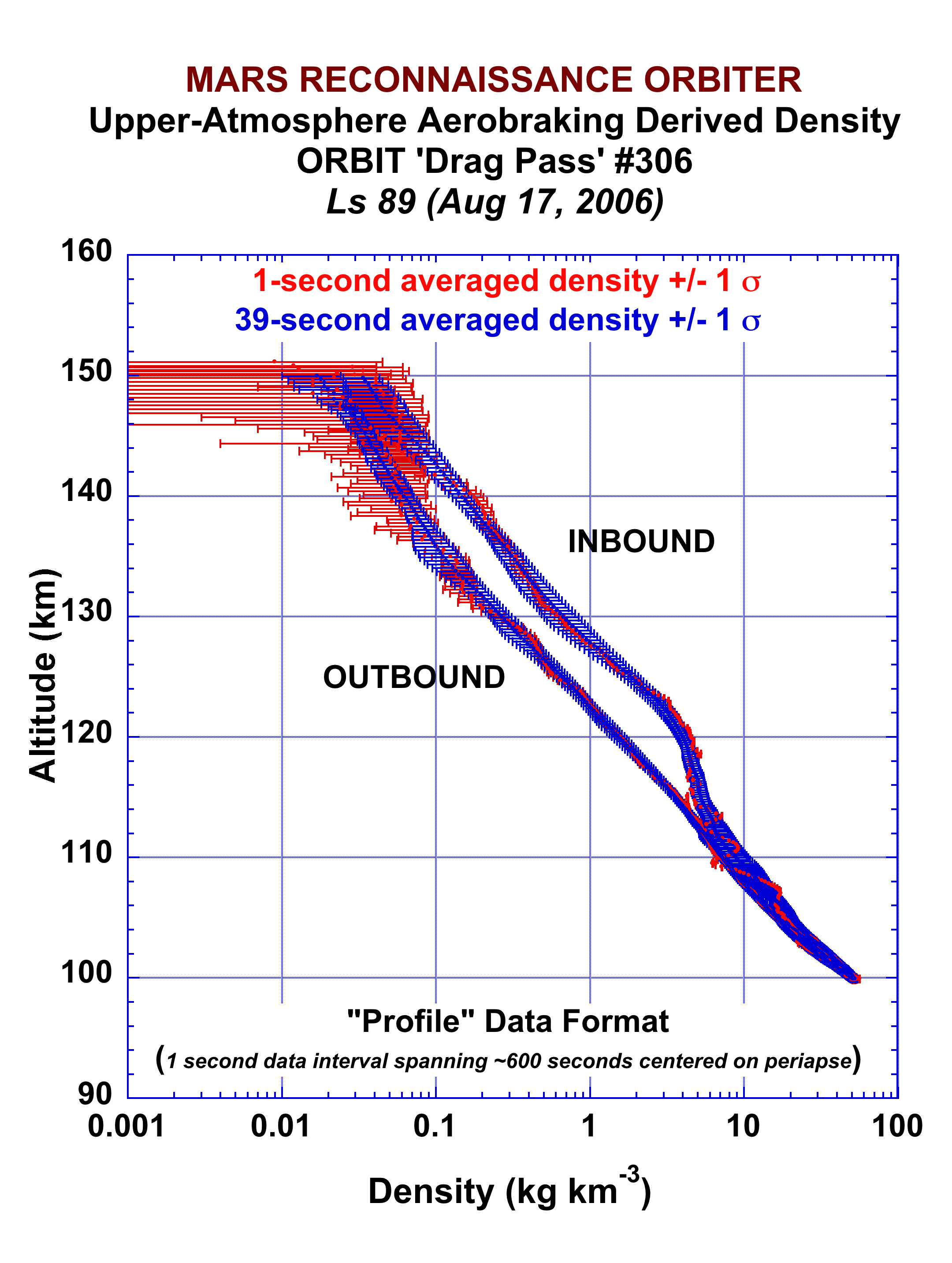
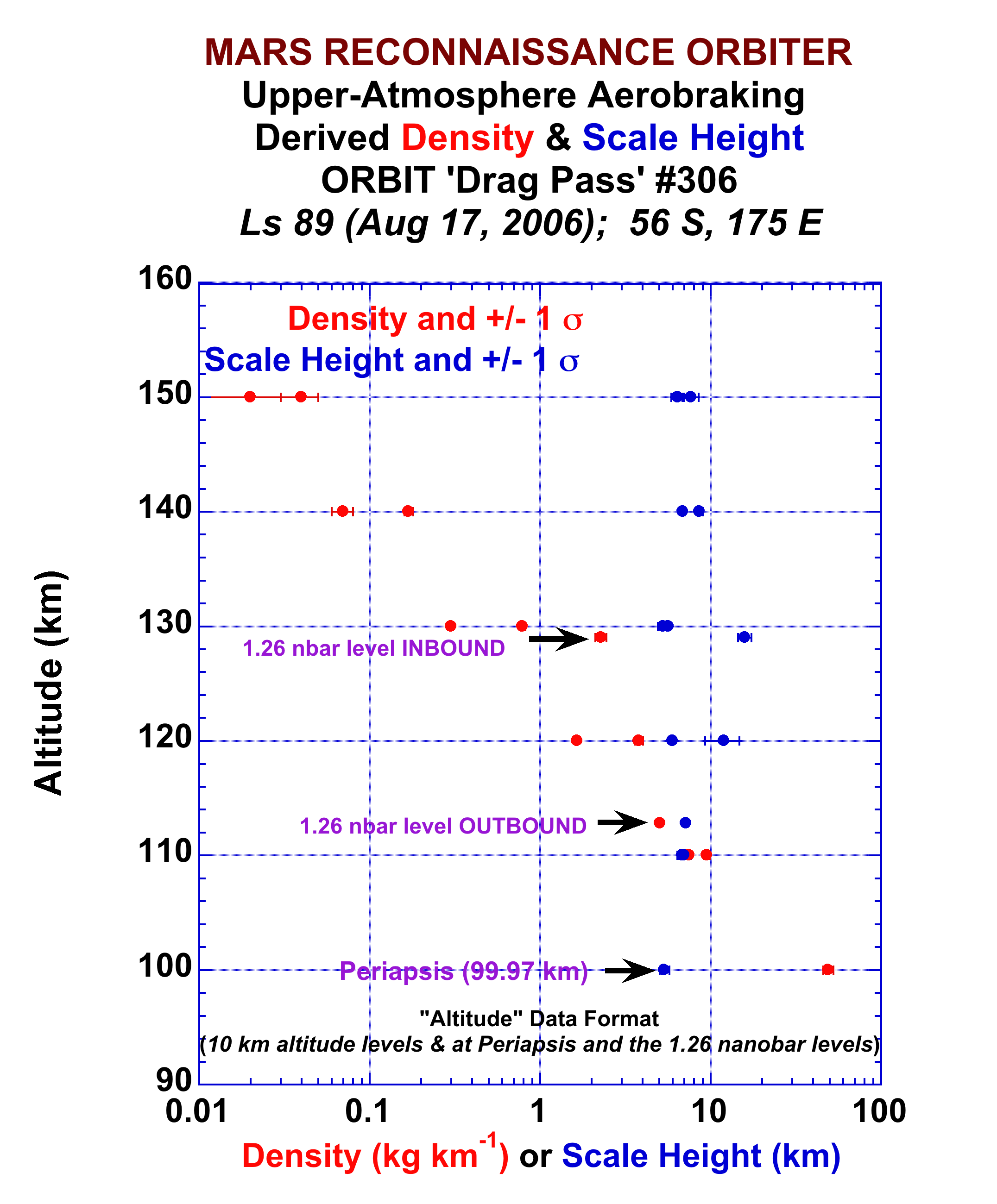
Examples of MRO Aerobraking Profile (left figure) and Aerobraking Altitude (right figure) data of atmospheric density and atmospheric scale height derived from measured spacecraft deceleration during an aerobraking drag pass (drag pass 306 for these graphed data). The data file that provided the Profile data in the above left graph is available here, and the file that provided the Altitude data in the above right graph is available here.
Useful Mission Documents
References
Tolson, R.H. et al., Application of Accelerometer Data to Mars Reconnaissance Orbiter Aerobraking Operations, 2007 AIAA/AAS Space Flight Mechanics Conference, Sedona, AZ.
Bougher,S.W.,J.R.Murphy,J.M.Bell,and R.W.Zurek, Prediction of the Structu/su///////re of the Martian Upper Atmosphere for the Mars Reconnaissance Orbiter (MRO) Mission, Mars, 2, 10-20,2006 DOI 10.1555/mars.2006.0002
For each drag pass (spanning orbits 18 - 445 of the mission) there is an individual ASCII Profile file containing derived density values at 1-second intervals for a time period spanning several hundred seconds centered upon the periapse time. There is also a separate ASCII Altitude file which provides derived density and scale height values at specified altitudes (100 km, 110 km, etc.) for both the inbound and outbound portions of that orbit/drag pass as well as at the periapsis altitude, and 1.26 nanobar pressure level during both the inbound and outbound portions of the orbit/drag pass.
The data contained within the MRO Aerobraking PDS archive mroa_0001 are provided in either the Altitude or Profile folders within the data folder. Within both the Profile and Altitude folders a user will find subfolders containing ~100 drag passes of data, with each drag pass consisting of a single ASCII file. For instance, the data presented in the left figure above are from the L2P306.TAB file located within the P300_399 folder within the Profile folder, while the data presented in the right-side figure above are located in the L3P306.TAB file located in the P300_399 folder located within the Altitude folder. The contents and structure of the TAB files are described within text within those data files. Raw MRO accelerometer data are also available within their own folder below the data folder.
Retrieving the data volume
Calibrated Data
Data can be retrieved at the file level - download the index, (csv) select the desired files and submit a list of URNs to retrieve the data Link this to a page to retrieve the data.
Raw Data
Similar aerobraking archives are available for the MGS and MARS Odyssey orbiter missions.
Citing Data Sets for Publications
G.M. Keating, S. Bougher, R.H. Tolson, S.P. Brown (2006), Mars Reconnaissance Orbiter Accelerometer Data, NASA Planetary Data System, https://doi.org/10.17189/1518937.
Mission Description
Spacecraft Description
Instrument Description
Guide to Accelerometer products
Calibration Data
Document folder
Spacecraft Description
Instrument Description
Guide to Accelerometer products
Calibration Data
Document folder
References
Tolson, R.H. et al., Application of Accelerometer Data to Mars Reconnaissance Orbiter Aerobraking Operations, 2007 AIAA/AAS Space Flight Mechanics Conference, Sedona, AZ.
Bougher,S.W.,J.R.Murphy,J.M.Bell,and R.W.Zurek, Prediction of the Structu/su///////re of the Martian Upper Atmosphere for the Mars Reconnaissance Orbiter (MRO) Mission, Mars, 2, 10-20,2006 DOI 10.1555/mars.2006.0002
CERTIFIED
Description of the DATAFor each drag pass (spanning orbits 18 - 445 of the mission) there is an individual ASCII Profile file containing derived density values at 1-second intervals for a time period spanning several hundred seconds centered upon the periapse time. There is also a separate ASCII Altitude file which provides derived density and scale height values at specified altitudes (100 km, 110 km, etc.) for both the inbound and outbound portions of that orbit/drag pass as well as at the periapsis altitude, and 1.26 nanobar pressure level during both the inbound and outbound portions of the orbit/drag pass.
The data contained within the MRO Aerobraking PDS archive mroa_0001 are provided in either the Altitude or Profile folders within the data folder. Within both the Profile and Altitude folders a user will find subfolders containing ~100 drag passes of data, with each drag pass consisting of a single ASCII file. For instance, the data presented in the left figure above are from the L2P306.TAB file located within the P300_399 folder within the Profile folder, while the data presented in the right-side figure above are located in the L3P306.TAB file located in the P300_399 folder located within the Altitude folder. The contents and structure of the TAB files are described within text within those data files. Raw MRO accelerometer data are also available within their own folder below the data folder.
Retrieving the data volume
Calibrated Data
Accelerometer profile data description
Accelerometer profile data
Data can be retrieved at the file level - download the index, (csv) select the desired files and submit a list of URNs to retrieve the data Link this to a page to retrieve the data.
Accelerometer profile data
Data can be retrieved at the file level - download the index, (csv) select the desired files and submit a list of URNs to retrieve the data Link this to a page to retrieve the data.
Example of Data (partial file)
Orbit 99
| Time from Periapse (sec) | Latitude (deg) | Longitude (deg) | Local Solar Time (hr) | Solar Zenith Angle (deg) | 1 sec Altitude (km) | Density (kg/km**3) | Sigma Density (kg.km**3) | 39 sec Altitude (km) | Density (kg/km**3) | Sigma Density (kg.km**3) | ||||||||||||||||||||||
|---|---|---|---|---|---|---|---|---|---|---|---|---|---|---|---|---|---|---|---|---|---|---|---|---|---|---|---|---|---|---|---|---|
| -196.3 | -81.9 | 243.6 | 3.6 | 118 | 151.41 | 0.013 | 0.038 | 149.76 | 0.019 | 0.011 | ||||||||||||||||||||||
| -195.3 | -82 | 243.4 | 3.5 | 118 | 150.91 | 0.014 | 0.035 | 149.35 | 0.021 | 0.011 | ||||||||||||||||||||||
| -194.3 | -82 | 243.2 | 3.5 | 118 | 150.41 | 0.017 | 0.023 | 148.74 | 0.022 | 0.012 | ||||||||||||||||||||||
| -193.3 | -82.1 | 242.9 | 3.5 | 118 | 149.91 | 0.008 | 0.026 | 148.11 | 0.024 | 0.013 | ||||||||||||||||||||||
| -192.3 | -82.2 | 242.7 | 3.5 | 117.9 | 149.41 | 0.012 | 0.026 | 147.69 | 0.026 | 0.013 | ||||||||||||||||||||||
| -191.3 | -82.2 | 242.4 | 3.5 | 117.9 | 148.92 | 0.008 | 0.026 | 147.11 | 0.027 | 0.014 | ||||||||||||||||||||||
| -190.3 | -82.3 | 242.2 | 3.5 | 117.9 | 148.43 | 0.017 | 0.03 | 146.56 | 0.029 | 0.015 | ||||||||||||||||||||||
| -189.3 | -82.4 | 241.9 | 3.4 | 117.9 | 147.94 | 0.0190 | 0.032 | 146.02 | 0.032 | 0.016 | ||||||||||||||||||||||
| -188.3 | -82.4 | 241.7 | 3.4 | 117.9 | 147.45 | 0.017 | 0.023 | 145.53 | 0.034 | 0.017 | ||||||||||||||||||||||
| -187.3 | -82.5 | 241.4 | 3.4 | 117.9 | 146.97 | 0.028 | 0.031 | 144.98 | 0.037 | 0.018 | ||||||||||||||||||||||
| -186.3 | -82.6 | 241.2 | 3.4 | 117.9 | 146.49 | 0.024 | 0.036 | 144.5 | 0.04 | 0.019 |
Data can be retrieved at the file level - download the index, (csv) select the desired files and submit a list of URNs to retrieve the data Link this to a page to retrieve the data.
Example of Data
Orbit 99
Orbit 99
| Altitude (km) | Latitude (deg) | Longitude (deg) | Local Solar Time (hr) | Longitude of Sun (deg) | Solar Zenith Angle (deg) | Density (kg/km**3) | Sigma Density (kg/km**3) | Scale Height (km) | Sigma Scale Height (km) | ||||||||||||||||||||||||||
|---|---|---|---|---|---|---|---|---|---|---|---|---|---|---|---|---|---|---|---|---|---|---|---|---|---|---|---|---|---|---|---|---|---|---|---|
| Periapse | 100.96 | -81.9 | 112.64 | 18.88 | 68.21 | 114.89 | 39.18 | 6.85 | 6.41 | 0.9 | |||||||||||||||||||||||||
| 1.26 nbar inbound | 112.91 | -86.33 | 172.49 | 15.85 | 68.21 | 116.6 | 5 | 0.02 | 7.24 | 0.06 | |||||||||||||||||||||||||
| 1.26 nbar outbound | 115.31 | -74.18 | 99.61 | 18.04 | 68.21 | 112.45 | 5.19 | 0.03 | 6.98 | 0.1 | |||||||||||||||||||||||||
| inbound | 100 | -1 | -1 | -1 | 68.21 | -1 | -1 | 0.01 | -1 | -1 | |||||||||||||||||||||||||
| outbound | 100 | -1 | -1 | -1 | 68.21 | -1 | -1 | 0.01 | -1 | -1 | |||||||||||||||||||||||||
| inbound | 110 | -86.38 | 159.52 | 21.98 | 68.21 | 116.43 | 7.46 | 0.04 | 7.31 | 0.1 | |||||||||||||||||||||||||
| outbound | 110 | -75.63 | 100.91 | 18.12 | 68.21 | 112.94 | 10.67 | 0.15 | 7.87 | 0.3 | |||||||||||||||||||||||||
| inbound | 120 | -86.19 | 204.06 | 0.94 | 68.21 | 117.01 | 1.91 | 0.01 | 7.57 | 0.1 | |||||||||||||||||||||||||
| outbound | 120 | -72.89 | 98.46 | 17.96 | 68.21 | 112.01 | 2.61 | 0.02 | 6.73 | 0.12 | |||||||||||||||||||||||||
| inbound | 130 | -84.89 | 226.23 | 2.41 | 68.21 | 117.41 | 0.49 | 0.01 | 7.01 | 0.15 | |||||||||||||||||||||||||
| outbound | 130 | -70.81 | 97.03 | 17.88 | 68.21 | 111.28 | 0.63 | 0.01 | 6.98 | 0.24 | |||||||||||||||||||||||||
| inbound | 140 | -83.46 | 236.9 | 3.11 | 68.21 | 117.72 | 0.11 | 0.01 | 6.42 | 0.23 | |||||||||||||||||||||||||
| outbound | 140 | -69.05 | 96.02 | 17.82 | 68.21 | 110.65 | 0.15 | 0.01 | 7.78 | 0.5 | |||||||||||||||||||||||||
| inbound | 150 | -82.09 | 242.96 | 3.51 | 68.21 | 117.96 | 0.02 | 0.01 | 6.88 | 0.24 | |||||||||||||||||||||||||
| outbound | 150 | -67.51 | 95.25 | 17.77 | 68.21 | 110.08 | 0.05 | 0.01 | 11.82 | 0.81 | |||||||||||||||||||||||||
Raw Data
Similar aerobraking archives are available for the MGS and MARS Odyssey orbiter missions.
Citing Data Sets for Publications
G.M. Keating, S. Bougher, R.H. Tolson, S.P. Brown (2006), Mars Reconnaissance Orbiter Accelerometer Data, NASA Planetary Data System, https://doi.org/10.17189/1518937.
