

July 4, 1976 (Ls 90) to Feb 13, 1979 (Ls 230)
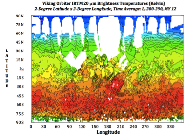
Surface "T20" temperatures (20 μm brightness temperatures) derived from Viking Orbiter IRTM measurements averaged (over 10 degrees of Ls, 280-290, MY 12 for 2-degree latitude by 2-degree longitude bins).
The temperature data in this IRTM data set are in the form of 10-degree Ls and 2-degree latitude by 2-degree longitude averaged values at times and locations where measurements were provided by the IRTM. All available data were included in these averaged temperature values, but temporal sampling is not necessarily uniform, nor was the spatial coverage (as illustrated in the figure).
Useful Mission Documents
Description of the DATA Document
The data contained within the Viking orbiter IRTM temperature archive provide the location (latitude, longitude), time (Ls and time-of-sol), and derived temperature and albedo values (and their standard deviations). In addition to the 20 μm surface temperatures the archive also provides atmospheric temperature (15 μm brightness temperature, T15) and differences between T20 and T7 (7 μm brightness temperature), T20-T9 (9 μm brightness temperature), and T20-T11 (11 μm brightness temperature), and two forms of derived albedo. Standard deviation values are available for each of these measurements.
Useful Mission Documents
Description of data volume
Mission Description
Spacecraft Description
Instrument Description
References
Mission Description
Spacecraft Description
Instrument Description
References
Description of the DATA Document
The data contained within the Viking orbiter IRTM temperature archive provide the location (latitude, longitude), time (Ls and time-of-sol), and derived temperature and albedo values (and their standard deviations). In addition to the 20 μm surface temperatures the archive also provides atmospheric temperature (15 μm brightness temperature, T15) and differences between T20 and T7 (7 μm brightness temperature), T20-T9 (9 μm brightness temperature), and T20-T11 (11 μm brightness temperature), and two forms of derived albedo. Standard deviation values are available for each of these measurements.
Calibrated data
The data is in a tabular ASCII form in the surface.dat file (186 Mbytes!) located within the data folder within the archive volume vo_3002. The contents of and structure of this data file are described in the file surface.lbl.
The data is in a tabular ASCII form in the surface.dat file (186 Mbytes!) located within the data folder within the archive volume vo_3002. The contents of and structure of this data file are described in the file surface.lbl.
