
Aug 01, 2008 (Ls 106.8) to Feb 25, 2012 (Ls 75.1)
Sunset view of the 70 m antenna at Goldstone, Ca.
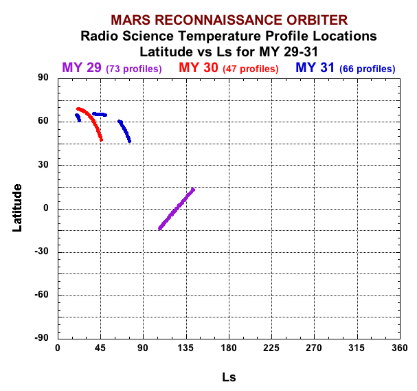
Latitude of derived MRO Radio Science temperature profiles versus seasonal date for the three Mars years spanned by the currently available derived profiles.
CERTIFIED
MRO Radio Science Data
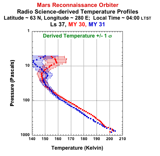
The MRO Mission goals did not include reduction of the MRO radio science occultation signals to derive temperature-pressure profiles. The mission goal was to use the radio signal to improve our understanding of the gravitational field of Mars. Thus, the raw Radio Science data records are archived at the Geosciences node with the derived-gravity data. This derived MRO T-P dataset is the result of detailed analysis by David Hinson (funded by the Mars Data Analysis Program) of the radio signal received from MRO as it entered and exited occultation by the planet. The spatial and temporal coverage in the radio occultation experiment are determined by the geometry of the spacecraft orbit and the dates and times at which occultation data were acquired. The current data set (which is expected to be added to as more derived profiles are generated) includes low latitude observations in 2008, latitudes >45° N in 2009 and 2010 and latitudes >60° N in 2011 dropping to less that 50° in February 2012. (See the similar MGS T-P dataset for additional spatial and seasonal coverage).
Derived Data - Temperature-Pressure Profiles
The data are located at mrors_2001. This data set is comprised of data products, each derived from an individual ingress or egress occultation. Each product lists observing parameters and a table including pressure, temperature and density and associated standard deviations as a function of radius (distance from the center of mass of the planet).
The tps directory contains 7 subdirectories with names of the form yyyy_ddd giving the year (yyyy) and day-of-year (ddd) of the first T-P file within it. The subdirectory coverage does not overlap and there are often days or weeks between the last file in one directory and the first file in the next.
Accessing the data
The following index (xlsx, txt) can be used to select desirable products and the aareadme file describes the dataset.
Additional Information
The Software Interface Specification (SIS) document provides a more detailed description of the data set while catalogue files in mrors_2001 define the mission, spacecraft and instrument.
Raw Data (EDR) See Geosciences node
Complementary dataset
See the MGS T-P dataset
